Saturday, July 2, 2022
Damodar Kunda Darshan Trek
Damadar Kunda is one the religious place for Hindus Devotees, and off the beaten trek for trekking lover. Because of its low accommodation facilities only few visitors do treks, but most of them book helicopter to visit this sacred place. If you look at the map you will see this Kunda on the northern side of Muktinath.
Day 1: Arrive in Kathmandu
Day 2: Fly/Drive to Pokhara
Here are two options:
I. Trek to Chrang by same route of Lo Manthang 5 days trek. trek to Lo and link to Damadar kund trek.
II. Drive to Chrang from Pokhara
But many trekker visit to Lo Manthang and then trek to Damador Kund
Day 4: Trek from Dri/Yara to Ghuma thanti ( visit to luri cave)
Day 5: Trek from Ghuma thanti to Kunda
Day 6:Trek from Damdor Kunda to Ghuma Thanti
Day 7: Trek to Tangge from Ghuma Thanti
Day 8: Trek to Ghumna thanti to Chhuksang
Day 9: Trek to Muktinath
Day 10: trek to Jomsom
Day 11: Fly to Pokhara
Day 12: Pokhara
Day 13: back to Kathanmandu
Day 14: your destination
Saturday, May 25, 2019
Nagarjun Hill Hiking
Hike from Nagarjun Gate to the Top of Nagarju Hill, often will pass out with the stone steps, dry leaves, greenery vegetation and birds calling. It will also be suitable for your family day hike. So, enjoy the hike.
Things to be noted ---
-318 Species of Birds
-Jamacho view point ( 2128 m)
-View the ranges of jugal himal, Ganesh Himal,
-It will be six hours hike up and down
- Do not forget have packed lunched
-Jamacho Monastery.( Nagarjuna buddha)
 |
| Let's start Hiking |
 |
| Bought entry ticket National Park |
 |
| People Need Nature |
 |
| Wilderness as your friends |
 |
| Little Wilderness |
 |
| View of Jamacho |
 |
| On the way to Jamacho |
 | |
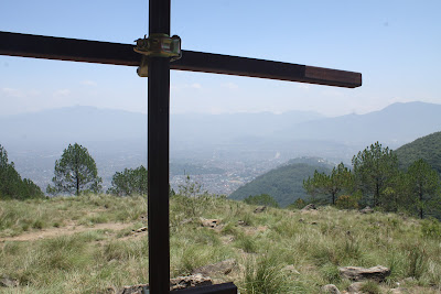
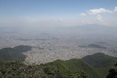
| View of Kathmandu Valley |
 | |
| Guru Rinpoche monastery |
 |
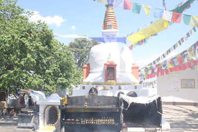
| Buddhist Temple at Jamacho |
 |
| Jamacho |
 |
| Rituals things burning down |
 |
| Poor Butterflies dies |
While hiking what I do not like to never forget to carry
Thursday, January 24, 2019
Budhi Gandaki River
Wild Wild West Nepal Adventure Tour
Khaptad Trek
Api base camp Trek
Saipal base camp Trek
Badimalika Trek
Urai Trek
Ramaroshan Trek
Suklaphanta jungle safari
Bardiya jungle Safari
Rara Tour
Dhangadhi City Tour
Ghodaghodi lake Tour.
Wednesday, January 23, 2019
Hiking Trail In Norway
Besseggen Ridge. ...
Dovrefjell. ...
Norangsdal Valley. ...
Preikestolen (Pulpit Rock) ...
Horseid and Bunes Beach. ...
Across the Hardangervidda. ...
Galdhøpiggen.
Subida al glaciar de Briksdal (Noruega).
Preikestolen - El Púlpito
RONDSLOTTET - RONDANE (Noruega) 2 días
TROLLTUNGA official track
Nordkalottleden - Arctic Trail (Kautokeino-Abisko)
Preikestolen (El Púlpito) 'Pulpit Rock'
BESSEGGEN
PREIKESTOLEN. NORUEGA
Haukland beach to Uttakleiv 2015-10-21
Norvège-FLAAM : rando cascade + église
Fjordroute Nordmore (Fjordruta Nordmøre)
Übergang von der Fjordroute Nordmore (Fjordruta Nordmøre) zum Trekanten (Trollheimen)
Das goldene Dreieck in Trollheimen: der Trekanten
Multistage tour Hardangervidda mit Søtefossen, Hårteigen und Hardangerjøkulen
3 Tage Rondane-Nationalpark (von Hjerkinn nnach Mysusaeter)
From Hardangervidda Finse to Overe Eidfjord
From Kapp to Cape - Thair Abud
Grenzpfad von Troms
Nordkalottleden, Nordkalottruta, Kalottireitti
Trondheim - Flughafen (Vaernes) Trip 2016 (Juli)
Noorwegen- Jotunheimen 2018
Backpack Route '420'
Harestua - Oslo 2 day hike
Lysebotn nach Suldalsosen
Through Trollheimen without the Trekanten (Triangle)
Kungsleden (Beide)mit verbindung E1
Rundweg Hardangerjökulen
Lysenfjord mit
NO-09b PREIKESTOLEN - BAKKEN2
Long distance hiking trails in Norway
https://ut.no/utforsker/?tab=trip
https://english.dnt.no/summer-trails/
Sunday, January 13, 2019
Langtang Trekking By Thakur
Friday, July 27, 2018
Inside Nar And Phu Trekking
: December to August US$ 75 per week per person or equivalent convertible foreign currency.
It is one of the best options after the manaslu trekking who want to continue highland adventure to Marsyangdi Valley Trekking and another option Annapurna Circuit
It is Possible to buy Permit at Koto or between Dharapani, on the way?
Only place to buy permit is Pokhara or Kathmandu (more to update?
You need passports, photos, the fees for permit
But if you want to update more about the trekking in Nar Phu, try asking with guide or agency.
To the Dharapani one can reach by the transport
The problem of network in Bhimtang.
One needs a permit and TIMS, this permit can be used as long as you are in Annapurna region
The Narphu is a Restricted Area and the permit can obtain from Ktm or Pokhara. One need a camping for more than 2 days ( 3 Day)
Option for vehicle
1 One can drive to Besisahar and start trekking
2.One can also drive to Manang and start trekking
Generally the you can find option provide by different adventure tour operator or trekking agencies of Nepal. As per there itinerary they would like to spend you nights at following points
Night at #1 Bulbhule
Night at #2 Ghermu (option during rainy season of Nepal
Night at #3 Chamje
Night at#4 Dharapani
Night at #5 Koto
Night at #6 Dharmsala
Night at #7 Somewhere between Phu valley
Night at #8 Phu village
Night at #9 Nar Phedi ( stayed at Monastery)
Night at #10 Nar
Night at #11 Kang La Phedi
Night at #12 Ngawal
Night at #13 Manang ( it will be long journey and take a rest)
Night at #14 Yak Kharka
Night at # 15 Thorung Phedi
Night at #16 Muktinath (Ranipawa)
From Muktinath generallly now days trekker hire a vehicle and drive to Beni and then to Pokhara. But Other option is one can trek to Ghorepani and then Nayapul, drive to Pokhara.
This is are overnight staying places generally the trekking agency offer for you. I have mention number of trekking lodges in trekking route( might have change)
Dharmasala camp easily trekking can obtain the room; many travel do not like to stay here because of its shit is every where
Meta Kharak have around 2-3 lodges
Chyaku best option for camping trekking but tea house are also offered by local.
Kyang niche place to stay tea house are offered by the locals
Phu village have basic 2-3 lodges offered by locals
Nar Phedi have limited rooms for sleeping, one of the best place for camp near monastery.
Nar village have nice lodges have 2-4 lodges
Kang la Phedi has no shelter facility and no toilet but now may have any Lodges
So manily camping is offered by trekking agency but trekking are also operate by the agencies
I suggest camping for 3 or 4 nights while you are in trekking during season and do not forget carry Tents and camping equipments.
Generally the campany provide you accompany guide through out trekking but you can also hire guide from KOTO. Using accompany guide I will suggest for trekker.
Saturday, June 2, 2018
Trekking Route in Magdi
The trekking route from Deurali to Phedi, the route was narrow and often damaged by a landslide. This route is 26 miles distance from Beni, take a whole day from Lulang passing out the forest and high hills.
Note: Gurja to Rghachour
One can find homestay services,
5 km distance
Saturday, April 21, 2018
Packing your hiking Bags
Planning your hiking, you need a food, water, and other necessary supplies. Think twice before deciding what goes inside your bag. Correctly packing your bags will along in your journey. Backpacking is a simple task but it creates a difference between comfortable and fantastic one in hiking.
Collect all your gear
Choosing a backpack
Gathering necessary supplies
Layout your supplies by weight
Consolidate items wherever possible
Putting your stuff
Limi Valley Adventure
One of the wilderness areas of Nepal, valley limited its surrounding from the border of the Himalayan pass Hilsa and Chang La between Tibet, China and Nepal. The land of few areas still the means of transportation mules, donkeys, horses are used.
Trekking in Limi Valley, commence your journey from Nepalgunj to Simikot by air, Simikot the administrative headquarters of Humla. Trekking in an ancient trading route of Nepal and Tibet, China with a glimpse of Mt. Kailash, Mt Saipal, Ghur-La Mana dala, Mt. Mendun.With the dense forest one can observe wold, wild yak, blue sheep, wild ass, hare, Himalayan back beer. Own dialect form of Tibetan descendants with their unique culture and traditions (Sharbu dance).
The panoramic view from Gyuckarka which lies at an altitude of 5000 meters able to see the Saipal, Kanjirawa, Kanti, Gorakh, Rishi Himalayan range. Nepal Government has issues limited and special permit fees even today for avoiding the disturbance of ecosystem. The thrilling adventure in Limi Valley with your trekking shoes, one of the earth rare land. At least two traveler is most.
Kathmandu to Nepalgunj
Nepalgunj to Simikot and trek to Dharapuri
Dharapuri to Sally Khola
Sally Khola to Muchu
Muchu Khola to Yari
Yari to Hilsa
Hilsa to Manepeme
Manepeme to Til
Til to Halji
Halji to Jang
Jang to Rest day for acclimatization
Jang to Yak Kharka
Yak Kharka to Viewpoint
Trek to Talung
Talung Base camp pass
Talung to Shingungma
Shingungma to Dhinga Laga
Dhinga Laga to Simikot
Flight to Nepalgunj to Kathmandu
Wednesday, March 7, 2018
Saturday, February 24, 2018
Types of Itinerary
-Detail itinerary 6D+5+1D
A. 6D+ 5
1. Date
2.Days
3.Distination
4.Distance
5. Difficult
6.Duration
And another 5 elements
1. Time
2. Transport
3. Accommodation
4.Altitude
5.Food
1D- Attraction of Days
Note: Make short as possible, short and suit
Grading or Difficult of Trekking
Grade A/Soft up to 2000 m approximately 16 km per day
Grade B / Medium up to 3000 meters approximately 12 km per day
Grade C / harStreneous up to 4000 m app. 8 km per day
Grade D/ technical challenging aboce 4500 m with high passes.
Functions and Role of Trekking Guide
A. Information and Communication
B. Service
Knowledge of Itinerary (Trekking)
Grading or Difficult of Trekking
C. Staff and Group Briefing
Group i:e: Members, Tourists3.
1. Types of Briefing
a.Introductory Briefing
b.Day Briefing
c. Spot Briefing
d. General Briefing
2. Subject Of Briefing
(Nepali Greeting, Nepali Table manner, Social norms, values, practises, countries rules and regulation, high altitude sickness and prevention, trekker discipline, does and done for trekker, flora and fauna of the region, nature, culture geography, history and religion, Itinerary and attraction of the day, safety and security, walking manner, refund and non-refundable policy, service include an exclusive policy.
3. Art of Briefing
:4P +3
(Pro-active, Positive, Polite, Perfect)
(Curious, Humour, Knowledge of the subject)
*NO debate only facts should be told them
*never Insult and make guilty
*our culture and tourists culture
D. Guest or Camp/Lodge Safety and Security
1.Safety
-Hygenic Food and drinkable water
-Always carry medical/kit box
-If necessary procced for helicopter rescue
-Use of toilet tents, gas and kerosene during the camping trek
-Manage waste disposable method
-clean your tented camp before you have to leave the place
-try to leave the only footprint to minimize negative impact when you are visiting
2.Security
-Always trek in a group/do not split the group
-Brief your staff of group all kind of security matter and make them responsible for their personal belongings
-But internally be responsible for all kind of security matter for your staff
-Select the safest place for you camp or loge
- Manage night security for camping trek
-keep good relation with locals and police where you are visiting
-Design and set your camp near to the other group
F. Trekking and Costing
-Local entry charges
-Personal Expenses
-Service charges
-Charges like Wifi, hot water shower,
G Handling Crisis
-Sick, including high altitude sickness
-Accident
-Nature disaster
-flight cancel
-Not enough accommodation
-complain by guest
-Roadblock (4412780)
-Conflict management between staff
Importance of Satisfied Guest
-re-visit
-Recommendation/word of mouth
-Effect marketing without spending money
Thursday, February 22, 2018
Sunday, December 31, 2017
Friday, November 3, 2017
Sagarmatha National Park III
An estimated 1,074 species of flora found in the Park (BPP 1995)
Records of 160 vascular plants, sixgymnosperms, 109 dicots, and 45 monocots
Records of 26 species of mammals, 162 species of birds, and 13 species of reptiles/amphibians from the Park (DNPWC 2003)
21 endemic species of flowering vegetation were recorded from national park (HMGN/MFSC 2002)
Thirteen species of mammals found in SNP are protected by CITES
6 species of mammals, 2 bird species are considered endangered and protected under of NPWC Act 1973
Mammal species symbolic of the park include the Snow leopard (Uncia uncia), a Musk deer (Moschus chrysogaster), and Red Panda (Ailurus fulgens),
Bird species symbolic of the Park are the Impeyan pheasant, Lammergeyer, Bearded vulture, Snow cock, and the Yellow-billed chough
First national park in Nepal to become accredited as a UNESCO World Heritage Site in 1979 for its exceptional area with mountains, glaciers, and deep valleys dominated by Mount Everest, the highest peak in the world


